IECA’s new conference and education manager shares his love for the environment with everyone from children to CEOs
BRAD PATERSON IS OUTDOORSY. He enjoys hiking, skiing, and backpacking, and he has been able to translate a love of nature and the environment into a career in environmental education. Recently hired as IECA’s conference and education manager, Paterson will now lead the planning, development, and execution of IECA education and events to advance members’ professional growth and success.
Born and raised in Colorado, Paterson attended Texas Christian University in Fort Worth, earning a degree in sociology and anthropology. He returned to his home state soon after graduation to work in environmental education with underserved youth, helping kids build life skills and employment readiness through outdoor adventures.
A gap year spent traveling Asia and the western U.S. with his fiancée reaffirmed Paterson’s belief in the interconnectedness of environmental systems, and he returned to school to get a master’s degree in environmental policy and natural resource management at the University of Denver. That led to a job with the city promoting community waste diversion programs with Denver Recycles.
Paterson eventually moved to Denver’s Office of Climate Action, Sustainability, and Resiliency (CASR), where he developed a specialty in finding nature-based solutions to environmental challenges. “Our mission was to protect vulnerable populations from climate change,” he says. “That was exciting work.”
One big success during Paterson’s tenure was a tree-planting program he developed to help cool Denver’s warmest neighborhoods. The program led residents to plant more than 1,700 shade trees on private property. Paterson’s work encompassed many municipal green infrastructure projects to enhance ecological health and biodiversity in ultra-urban areas. He has seen firsthand the many applications of responsible erosion and sediment control in a growing and environmentally conscious city.
Whether he’s educating schoolchildren or CEOs, Paterson says it’s important to provide new insights that inspire a sense of wonder. “Water and soil resources are interconnected,” he says. “One of my goals is to protect [those] resources, and the other is advancing learning among IECA members by taking their lead on what they want to know and matching education to that. “It’s a privilege to join a global network of professionals who are not only passionate about protecting our natural resources but also committed to education, innovation, and collaboration across industries and borders,” he adds. “I’m extremely honored to support IECA members in achieving their professional goals. I’m ready to work hard for the community.”
AS I WRITE THIS, it’s just hours until I am due to collaborate with a customer’s leadership team on the company’s annual strategic plan. We will take an objective look at the past year and its good, “meh,” and ugly outcomes; look at the market’s components; and use our creativity and best judgment to forecast the future. It’s the most important meeting of the year, and it may well determine our success—or lack thereof—for the next two.
These sessions are full of excitement, trepidation, collaboration, and creativity. When done with people who want to enhance organizational strengths, recognize where improvements might be needed, embrace change, and leverage business fundamentals, extraordinary things can happen. Success doesn’t flow from chance; it flows from a strategy founded in clear insights.
To put it into the language of erosion control, the smartest companies don’t just manage runoff; they manage revenue, margins, and run rates and blend them with environmental intelligence and business acumen to create predictable, resilient, profitable, and sustainable organizations.
Business as an Ecosystem
To do this, you must think of your business as an ecosystem and read your market as closely as you would read a site plan. Only then can you can chart the currents that drive opportunity and mitigate risk. Knowing the most important players in your market will help you build a strategic plan for the future.
We start with our customers—those who truly value long-term sustainability and understand the need to balance compliance with creativity, proactivity with practicality, engineering with environmentalism, and best management practices (BMPs) with business. Whether working with municipalities, departments of transportation, engineers, or developers, the best clients see compliance as an investment, not a cost.
Next, look at your partners and sales channels; they are the market players and tools that determine how customers find you. From distributors to landscape contractors and environmental consultants, who helps you execute projects flawlessly and win new ones? Do you find customers through bid lists, certifications, or partnership networks? Whatever the method, streamline your go-to-market flow.
Then, take an objective look at the competition. What’s their niche—is it product innovation, price, or project speed? Differentiate your company with purpose and performance. And don’t look at suppliers as materials and inventory specialists but as educational and training partners. Your supply chain helps define your credibility.
Engage with and contribute to credible professional associations such as IECA and local stormwater groups to stay ahead of codes, training, education, and policy shifts.
Once you map these six inputs, patterns will emerge to reveal where the momentum of the market is going, and where new value pools such as green infrastructure, regenerative design, and nature-based solutions are forming.
Smart companies don’t fight the current; they design and lead strategy with it. The companies that are thriving today treat stormwater not as waste, but as an opportunity to protect resources, reduce risk, and build resilient communities and profitable organizations.
Before you propose another project, read your market. In erosion control—as in nature—those who understand the flow will lead the future.
About the Expert
Judith M. Guido is the chairwoman and founder of Guido & Associates, a business management consulting firm in the erosion control and green industry. Guido can be reached at 818.800.0135 or judy@guidoassoc.com.
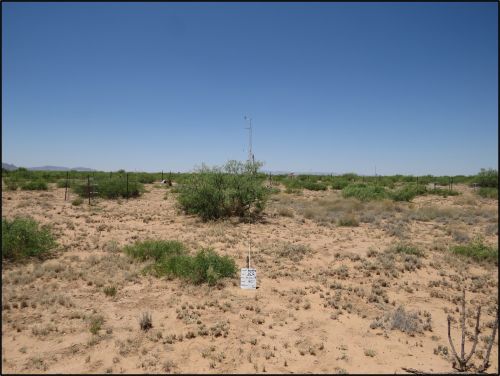
1. Aerial image of U.S. 30 Highway construction in Tama County, Iowa, USA, that shows the
existing two-lane route and the adjacent expansion, which includes four travel lanes, a median and
shoulders.
Linear construction, such as the highway projects managed by Departments of Transportation (DOTs) in the United States, presents a unique set of stormwater management challenges. Due to limited right-of- way (ROW) and numerous off-site discharge points, these projects often lack the space for traditional stormwater controls like large sediment basins or natural buffers.
Linear construction projects typically involve extensive clearing and grading, which increases the risk of erosion and sediment-laden runoff. Although best practices such as minimizing disturbance, phasing work and improving site communication can help, some areas will inevitably remain exposed during active construction. In these areas, it is crucial that erosion and sediment control practices are effective.
In recent years, research has been conducted to provide performance-based design, but it has largely relied on large-scale, controlled research settings. The goal of this work was to see how the designs translated to field conditions. To answer that question, the Iowa DOT sponsored a large-scale field study along a 12-mile (19-km) stretch of U.S. Highway 30 in Tama County, Iowa, United States. The project involved replacing a two-lane road with a new four-lane highway, complete with a median and shoulders (Cover photo). Researchers focused on three primary areas — perimeter control, ditch checks and detention practices — as researchers and the technical advisory committee decided these practices were potentially the most impactful for sediment control due to their frequency of use. The evaluation period for perimeter control and ditch checks occurred across five months and experienced a cumulative rainfall of 12 inches (30.5 cm). Detention practice monitoring occurred over two construction seasons, but it was paused during freezing conditions to avoid damage to automated water sampling and monitoring instruments. Soil samples from the site indicated a lean clay with sand (CL-SC), according to the Unified Soil Classification System.
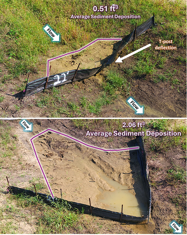
Perimeter Control In total, six silt fence designs were evaluated. The standard design used woven geotextile fabric trenched into the ground or sliced in and attached to t-posts spaced 8 feet (2.4 m) apart. However, t-post deflection, undercutting and geotextile tearing were regularly documented as problem areas for this configuration. Modifications were suggested to improve these problem areas and included:
Reducing post spacing to 5 feet (1.5 m)
Adding wire reinforcement
Offsetting the geotextile fabric 6 inches (15 cm) from the t-post line before keying into the ground
Evaluating trenching vs. slicing methods
Weekly inspections, including aerial imagery acquired by unmanned aerial systems (UASs), revealed that wire reinforcement and reduced spacing improved structural integrity. However, contractors found wire reinforcement more difficult to install. As a result, reducing post spacing was recommended as the most practical improvement. Also, the offset was recommended, as it had no additional cost associated and seemed to minimize dislodgement of the geotextile from the ground over time.
Ditch Checks Silt fence and wattles were evaluated as ditch checks. Evaluation of the ditch checks included structural integrity, sedimentation and impoundment. The structural integrity was visually monitored through weekly photo inspections and channel surveying. Sedimentation was measured using channel surveying and aerial imaging.
The standard silt fence ditch check design used 4-feet (1.2-m) post spacing and geotextile fabric trenched or sliced into the ground. Modifications included:
V-line installation with a dewatering weir
3-feet (0.9 m) post spacing
Wire reinforcement
6-inch (15-cm) offset
The most effective configuration featured all four modifications and captured four times more sediment than the standard. However, contractors noted that the V-line installation was difficult due to the required 45-degree slicing angle. The standard and modified installations are shown in Figure 2.
Figure 2. Silt fence ditch check standard and modified design with V-line, decreased post spacing and wire reinforcement
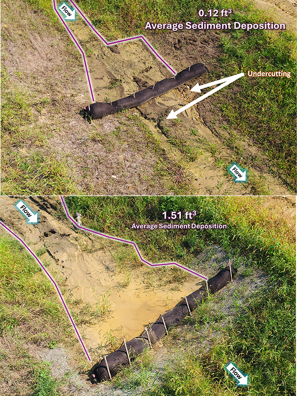
The standard wattle ditch installation specified that wattles should be installed perpendicular to the flow direction channel and staked through the media every 2 feet (0.6m). Modifications included:
A natural fiber underlay
Pinning the wattle to the ground
A-frame staking to reduce damage and buoyancy
The modified installation increased sediment capture by 12 times when compared with the standard design. The Iowa DOT has since adopted this modified wattle design into its standard practices. The standard and modified installations are shown in Figure 3.
Figure 3. Wattle ditch check standard and modified design with fiber underlay, A-frame staking and pinning.
Sediment Basin Additionally, the research team identified a unique sediment basin design that used an in-channel approach to create a detention environment. To achieve this, an earthen berm was constructed across the drainage channel along the shoulder. A riser pipe was installed through the berm to allow for controlled dewatering, and an auxiliary spillway was cut and armored with erosion stone. The team monitored a single basin and a series of two basins to evaluate turbidity reduction.
The site soil was fine, with a d50 0.025 mm, and, therefore, required settling times that exceed the residence time of water detained in the basin. Ultimately, the results showed negligible turbidity reduction over two construction seasons. However, the in-channel design was considered an innovative solution for managing stormwater within the limited ROW that is typical of linear construction sites. As a result, several design modifications were recommended for further testing, including geotextile stabilization, surface dewatering using a skimmer, flow baffles to distribute flow across the width of the basin and the addition of an upstream forebay. Although these modifications were not tested on-site, they prompted the initiation of a separate project focused on controlled, large-scale testing of basin components.
Unlike lab studies, field research captures the messy realities of construction: contractor installation practices, upstream activity, unpredictable weather and real-world maintenance (or lack thereof). No maintenance was performed during the study, which offered rare insight into the longevity of erosion and sediment control (E&SC) practices. The use of an Unmanned Aerial System (UAS) also proved invaluable by providing aerial perspectives after storm events, which would be difficult to capture otherwise. This research highlights the importance of adapting E&SC practices to the unique constraints of linear construction. By testing and refining designs in the field, DOTs can make data-driven decisions that improve water quality, reduce maintenance and support infrastructure development. Even small changes, such as adjusting post spacing or adding a fiber underlay, can make a big difference when tackling stormwater challenges on linear sites.
For more information, read: Schussler JC, Kazaz B, Perez MA, et al. 2021. Field Evaluation of Wattle and Silt Fence Ditch Checks. Transportation Research Record, 2675:281-293. Or visit the fact sheet at bit.ly/45FDF2R.
About the Expert • Jaime C. Schussler, Ph.D., PE, CPESC, is an assistant professor, School of Civil and Environmental Engineering, Oklahoma State University. She received her Ph.D. from Auburn University, where she conducted research for the Iowa DOT. She is a member of the International Erosion Control Association (IECA) Standards and Practice Committee and South-Central Board. • Billur Kazaz, Ph.D., PE, CPESC, is an engineer at Geosyntec Consultants, Kennesaw, Georgia, United States. Kazaz focuses on erosion and sediment control, construction stormwater management, construction site UAS and GIS. She is a member of the IECA Editorial Review Board and IECA Southeast Board. • Michael A. Perez, Ph.D., PE, CPESC, is the Brasfield & Gorrie associate professor, Department of Civil and Environmental Engineering, Auburn University. Perez is the director of Auburn’s Stormwater Research Facility, which provides interdisciplinary research, product evaluation and hands-on training.
Warren Faircloth
2025 Winner
IECA Lifetime Achievement Award
One Man’s Journey to a Sediment Solution
Warren Faircloth took jobs nobody wanted and worked in a new field where “no one knew what they were doing.” Along the way, he established meaningful collaborations and found abundant opportunities. Faircloth determined that sediment control could be successful, and he stimulated research into erosion and sediment control that proved him right.
At NC State University, Faircloth obtained a geology degree. After college, he worked for seven years in agricultural conservation for the Chatham and Orange County Soil and Water Conservation Districts in North Carolina, United States. That first job was a temporary one that nobody wanted, “but it ended up being a great opportunity for me,” Faircloth said.
He spent 18 years in erosion control. Faircloth oversaw the erosion control ordinance on construction in Orange County and Chapel Hill, North Carolina. Faircloth gained a reputation for being a natural educator and someone who stayed calm and professional in adversity. When he uncovered a difficult situation, such as someone grading without a permit, he would calmly and respectfully educate those seeking permits. Faircloth aimed to find the best solution for each party.
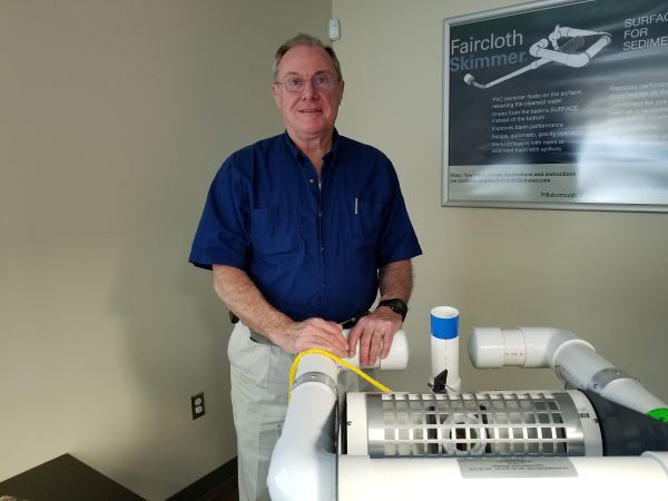
This position gave him a front-row seat to urban erosion and sediment control. It was a new field with plenty of problems and few solutions. One major problem, which seemed prevalent at all construction sites, was the poor performance of onsite sediment basins. Though they were meant to reduce sediment discharge, he found that most did not seem to improve water quality. The solution, to discharge the cleanest water from as close to the water surface as possible, seemed simple enough. Faircloth started gluing together PVC pipe. He created a device that would float on the surface, regulate filling/draining and release the cleanest surface water.
Faircloth convinced a developer in Chapel Hill to let him install “this crazy-looking device” in a sediment basin. Then he waited for rain. And waited. He had to wait two months. After it eventually rained, Faircloth realized his device made a dramatic difference in the sediment that was below in the watercourse. His skimmer is one of the things he’s most proud of.
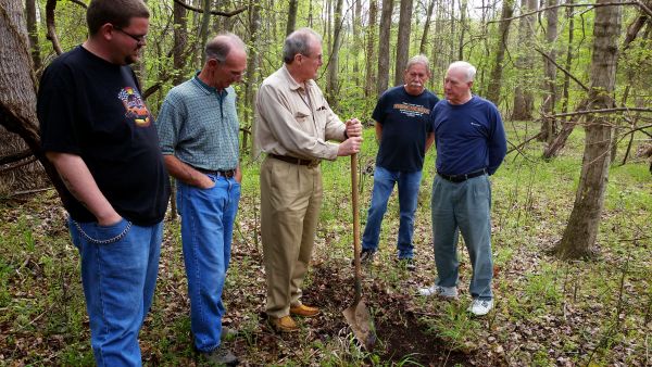
Figure 1. Faircloth with a display skimmer.
Faircloth’s creation helped stimulate research. His journey began with an article he stumbled across in the Journal of Soil and Water Conservation. A graduate student and his professor in the Department of Agriculture and Biological Engineering at Penn State University published a paper about the student’s experiments with sediment basins. They had tried to build a surface drain and could not get it to work. So Faircloth copied some of his slides and sent them to the professor, Albert Jarrett, Ph.D., PE. The professor was very interested.
Faircloth traveled to Penn State and showed up in Jarrett’s doorway with his skimmer in his hand. The professor had an immediate reaction that indicated yes, that’s what the skimmer should look like. For Faircloth, who says he wasn’t a good student in college, the professor’s reaction was probably the most satisfying moment of his life. Faircloth ended up sponsoring some of the sediment research at the University. Jarrett encouraged Faircloth and promoted his skimmer idea in Pennsylvania, USA. That area ended up being his first market when he was making skimmers on the side of working full time.
Figure 3. Faircloth talking with driver on job site.
Later, Faircloth helped stimulate the building of a lab by the Department of Crop and Soil Sciences at NC State University. NC State took a lead role in education about sediment basins. When the professor leading the research (Rich McLaughlin, Ph.D., who authors Environmental Connection’s Research Briefs) retired, Auburn University picked up the research efforts.
Over these years, Faircloth attended chapter meetings and annual conferences of the International Erosion Control Association (IECA), which he recommends to those starting in the field. “Get as much education as you can,” he advised. He also benefited from interacting with fellow attendees and hearing about their successes and setbacks. He was even known to grab a few graduate students at the annual conference and treat them to a nice dinner, just to get to know them and learn about their research projects. In 1995, a paper Faircloth submitted on his skimmer earned him the Technical Paper of the Year award from IECA.
After spending four years making skimmers, Faircloth and his wife, Margaret, founded Faircloth Skimmer in 2000. He was just a few years away from reaching full retirement benefits in his government job, but his wife was supportive of the new venture and lent her skills. They made a good team. Faircloth knew the technical and manufacturing side, and Margaret knew how to multitask and make good business decisions. “She was the brains behind the business,” Faircloth said. In 2007, Faircloth won the ICEA Environmental Achievement award. He also won the 2023 Sustained Contributor Award from the South East Chapter of IECA.
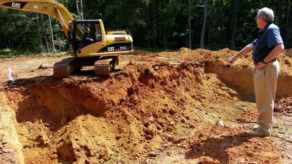
Figure 2. Faircloth, with employees, breaking ground for building.
Now that he’s sold the business and officially retired, Faircloth is putting his time into mentoring a high school robotics team that is sponsored by Faircloth Skimmer. He also enjoys collecting models of construction equipment and reading books about history, construction machinery, engineering and invention. The creative process fascinates him. Initially, Faircloth wanted to be an engineer, but “I ended up doing what I wanted to do.” Faircloth recently was awarded IECA’s Lifetime Achievement Award, the organization’s highest award. It recognizes individuals who have demonstrated extraordinary dedication, leadership and impact in the erosion and sediment control, stormwater management and environmental conservation industries.
“It’s very gratifying that, you know, the 30 years or more that I’ve put into this have benefited the environment, the community I live in,” Faircloth said.
Figure 4. Faircloth on a job site.
About the Experts • Joy Dickinson is the editor of Environmental Connection.
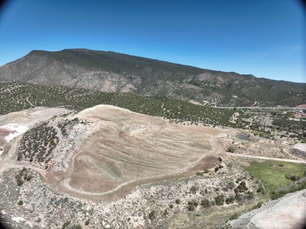
Quarry 1 before reclamation was a steep, highly visible and severely eroded limestone quarry with exposed rock faces and minimal vegetation.
In the mountains just east of Albuquerque, New Mexico, USA, a formerly mined landscape (Figure 1) has undergone a quiet yet remarkable transformation. What was once a steep, eroded limestone quarry — highly visible from the surrounding community and Interstate 40 — is now a sculpted, revegetated landform that mimics the natural terrain and supports native ecosystems. This transformation is the result of the reclamation of Quarry 1 (Figure 2), a project that has redefined what sustainable quarry reclamation can look like, by the author’s company.
Quarry 1 was no ordinary reclamation job. The site presented steep slopes, degraded soils and years of visual and ecological disturbance. Yet there was an opportunity in the challenge: a chance not just to meet regulatory obligations, but to restore the land in a way that would contribute to regional biodiversity, support long-term watershed health and serve as a positive example of industrial responsibility.
At the core of this reclamation effort was commitment to geomorphic design, which is a process that uses natural topographic patterns as the blueprint for reshaping the land. Rather than implementing traditional straight benches and uniform slopes, the project team used computer-aided design modeling and drone data to design a landform that mimics natural hills and valleys. This approach improves erosion control, integrates with surrounding terrain and provides the structural foundation for a self-sustaining ecosystem.
The execution of this design required technical precision and field adaptability. GPS-enabled earthwork equipment allowed for exact placement of materials, while high-frequency drone surveys informed real-time adjustments to the landform as it was built. This close coordination between field crews, engineers and environmental consultants allowed the author’s company to work dynamically and fine-tune slopes, drainage channels and planting areas as construction progressed.
One of this project’s most notable features is its approach to stormwater management. The reclamation includes a custom-engineered Rocky Bottom Channel (RBC) system that directs runoff across the site through shallow, vegetated drainage paths. Unlike conventional riprap-lined ditches, the RBC channels are designed with flat bottoms, earthen banks and strategically placed rock to slow water, encourage infiltration and support plant growth. The result is a stormwater system that is functional and ecological, reducing erosion while contributing to habitat complexity.
Figure 2. Quarry 1 after reclamation is a stable, natural-looking landscape with rolling hills, native vegetation and drainage features.
Equally innovative is the approach to revegetation. Understanding that plant establishment in arid environments can be slow and difficult, the team implemented “vegetation islands,” which were groupings of native plants installed in key locations across the site. These islands act as seed banks and wildlife attractors and accelerate natural colonization over time. Plant species included piñon and juniper trees, cottonwoods in low areas and a diverse mix of grasses and forbs adapted to the high desert environment.
To further enhance ecological function, bluff features and rocky outcrops were constructed throughout the site. These provide shelter and nesting opportunities for birds, small mammals and reptiles, and they help diversify the microhabitats available within the reclaimed area. The goal was not just to cover the site with vegetation but to build an ecologically functional landscape that could support a range of native species for decades.
Beyond the environmental engineering, the reclamation of Quarry 1 also offers visual and community benefits. The site is visible from a major interstate highway and nearby residential areas, which makes it a part of the public’s everyday landscape. The transition from a stark, visibly disturbed quarry to a naturalized terrain not only improves aesthetics, but it also demonstrates the company’s commitment to being a responsible neighbor and long-term land steward.
This project is also an example of how proactive engagement and internal innovation can push the boundaries of what is expected in reclamation. While the project met all regulatory requirements, the project went beyond minimum standards in multiple ways: designing a more complex drainage network, reducing the use of hardscape materials, investing in advanced grading technology and committing to long-term vegetation success through reseeding and monitoring.
The impact of these decisions is already evident. The site shows strong initial plant establishment, with early vegetation reducing windborne dust and stabilizing soils. Stormwater is moving effectively through the site’s designed channels, which minimizes erosion and supports infiltration. Wildlife activity has been observed in the reclaimed area, which signals a positive ecological response. And the landscape itself has changed by blending more seamlessly with the surrounding hills, no longer a scar but a sculpted, living part of the region.
The success of Quarry 1 reflects more than just good reclamation practice. It embodies a philosophy of land stewardship that aligns with modern expectations of environmental responsibility in heavy industry. In 2024, a revegetation trial plot established at Quarry 1 helped refine seed selection and won the Excellence in Reclamation Award from the New Mexico Mining and Minerals Division of the New Mexico Energy, Minerals and Natural Resources Department.
But perhaps the largest impact of the project is its role in shaping how reclamation is viewed: not as the end of a quarry’s story, but as the beginning of a new chapter for the land. Through careful planning, collaboration and a willingness to innovate, the project has shown that even the most challenging sites can be restored in ways that are ecologically meaningful, visually compelling and socially valuable.
As more mining and industrial sites approach closure, the lessons from Quarry 1 are increasingly relevant: that post-mining landscapes can be more than safe; they can be sustainable, beautiful and resilient. The work in Tijeras offers a model worth replicating and a compelling case for raising the bar in land stewardship across the industry.
About the Expert
Miranda Moore is the environmental engineer for the GCC Rio Grande Cement Plant in Tijeras, New Mexico.
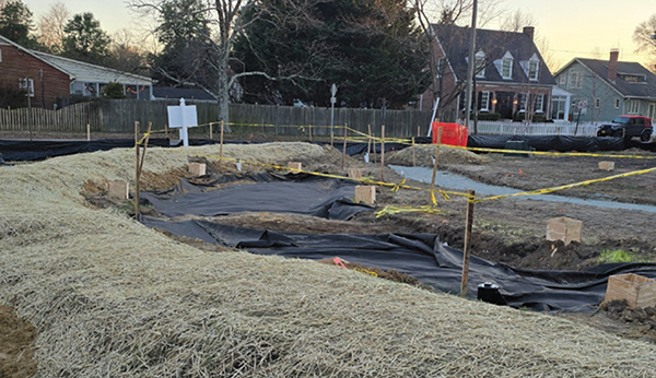
Green stormwater infrastructure implementation at the Ginter Park Branch – Richmond Public Library, City of Richmond, Virginia, USA.
From Compliance to Long-Term Impact
Once construction activities conclude, the crews drive away, and engineers sign their final documents. However, for Municipal Separate Storm Sewer Systems (MS4s), the work is far from over. A newly developed site is more than a collection of buildings and pavement; it’s a reshaped hydrologic system. Replacing lawns, meadows, urban forests and vacant land with buildings, airports, parking lots and other forms of impervious surface comes at a cost to water quality, flood management and municipal budgets. These changes in how water naturally moves increase the volume (amount) and velocity (speed) of stormwater runoff, leading to stream bank erosion, sedimentation and waterbody impairment.
MS4 operators, such as cities, military bases or universities, are required to manage these impacts. MS4s fall under Environmental Protection Agency (EPA) and state regulations, with compliance regulations varying based on location and population size. MS4 stormwater regulations come in three phases:
Phase 1. Large cities and districts
Phase 2. Smaller municipalities
Phase 3. Niche sites (military installations and universities).
MS4 operators are charged with tracking and monitoring infrastructure, inspecting sites for compliance, educating the public developing stormwater pollution controls, while balancing citizen concerns, local politics, economic development and integration of new regulations.
Post-construction stormwater controls are now a standard requirement under the EPA’s MS4 permit framework. As nationwide concerns over urbanization’s impact on water quality and flooding became a high-priority talking point for many communities, the EPA was prompted to establish more secure stormwater management standards. As one of the newer elements of stormwater management, MS4s face a familiar rite of passage: designing, implementing and maintaining an unfunded mandate that only a few years ago did not exist.
This article examines what happens after the initial MS4 rollout. As early implementation efforts move past short-term construction oversight to long-term stewardship of stormwater, infrastructure and compliance, MS4s are grappling with four common challenges: limited staff, unclear enforcement mechanisms, a lack of tracking assets and a lack of best management practices (BMPs). But with every challenge comes an opportunity to enact policies and procedures aimed at sustainable resilience.
Figure 2. Green stormwater infrastructure implementation at Ginter Park Branch – Richmond Public Library, City of Richmond, Virginia, USA.
Post-Construction Requirements Under the EPA’s National Pollutant Discharge Elimination System (NPDES) program, MS4 operators are mandated to develop, implement and enforce a post-construction program aimed at reducing pollutants from new development and redevelopment projects that disturb one or more acres (4,046 or more square meters) of land.
Each program must include:
A combination of structural and/or non-structural BMPs
Regulatory mechanisms, such as ordinances, to require implementation
Provisions for long-term operation and maintenance
Defined measurable goals to evaluate program effectiveness¹
Each goal must be:
Tailored for the local environment and community
Supported by metrics that can demonstrate pollutant reduction, runoff mitigation and BMP maintenance compliance
Integrate regional regulations, such as green infrastructure, low-impact development and off-site mitigation, and market-based mechanisms
Figures 1 and 2 are different perspectives of a small local library retrofitting its front lawn to integrate green stormwater infrastructure that is functional, aesthetically mindful and inviting to the local community. The mini retention pond works as a Post-Construction BMP and a children-sized amphitheater for outdoor read-alongs.
Figure 3. Shelby Farms Park Lake used as part of the post-construction plan by the City of Memphis, Tennessee, USA.
Three Challenges After Implementation
Permit and Ordinance Language While federal and state permits aim to provide flexibility in implementation for communities, many stop short of defining how reductions in stormwater pollutants should be operationalized. Without clear definitions of what qualifies as “long-term maintenance” or supplying performance standards for Maximum Extent Practicable (MEP) of controls, interpretations and standards of implementation vary widely.²
Local programs administered without enforceable ordinances or clear legal agreements result in voluntary compliance, as there is no clear mechanism to compel owners to maintain stormwater systems. Often, MS4s discover this issue only after a major disturbance or repeated complaints surface.³
Lack of Stormwater Asset Management While wastewater and drinking water systems have standardized structural assets (pipes, valves, pumps, etc.) and are primarily owned by the MS4, stormwater systems differ. Stormwater systems are often decentralized, privately owned and/or poorly mapped. Older asset management systems were not designed to account for the diversity of stormwater infrastructure, from proprietary devices to green infrastructure. The lack of asset management systems and accurate inventories hinders tracking, monitoring and performance reporting for MS4 post-construction programs.⁴
Stormwater assets could include storm inlets, an engineered culvert, the neighborhood ditch or a large recreational area (Figure 3). The City of Memphis maintains and manages Shelby Farms, which is home to a herd of buffalo, a community garden, hiking trails and a large detention pond used for water storage, kayaking and other recreational activities.
Staffing and Capacity Constraints Many MS4s implemented MS4 post-construction programs without acquiring additional staff, budget or training. Field crews already assigned to street maintenance, industrial inspections or code enforcement might deprioritize an MS4 post-construction program that lacks leadership support and direction.
In the absence of clear Standard Operating Procedures (SOPs) and role clarity, inspections may be infrequent, seasonal or partial programs directed primarily at new development, excluding existing BMPs.
Enforcement of MS4 post-construction requirements depends not only on authority but also on technical competency. Without adequate training on approved stormwater control measures, inspection protocols and maintenance standards, field crews may overlook issues or delay enforcement. In these cases, regulations risk becoming symbolic rather than actionable⁵
Three Opportunities for MS4 Program Maturity
Codify Maintenance Obligations Operation and maintenance agreements, paired with site-specific maintenance plans tailored to each installed BMP, provide clarity for property owners and strengthen accountability. Long-term enforceability is achieved when MS4s require these agreements and plans to be recorded with property deeds, which ensures that maintenance responsibilities transfer with the parcel regardless of ownership changes.⁶
GIS and Digital Asset Management Programs The range of available asset management technologies has grown significantly, which gives MS4s of all sizes affordable and scalable options for monitoring and maintaining stormwater infrastructure. Today’s GIS-based systems integrate critical data elements such as inspection history, risk tiering, maintenance logs, site photos and public records into centralized, user-friendly platforms.⁷
These tools reduce onboarding time, simplify training through standardized templates and provide clearer oversight. With better visibility, MS4s can shift from a reactive posture to a proactive, risk-based management approach, identifying potential issues early, prioritizing resources and forecasting long-term maintenance costs.8
Scalable SOPs and Frameworks SOPs and structured decision frameworks are essential for building consistency across MS4 post-construction programs. They establish clear, repeatable steps for inspections, documentation and enforcement, which creates alignment across departments and ensures that key tasks aren’t dependent on individual staff knowledge or memory.
While developing robust, field-ready SOPs requires significant upfront effort, it ultimately reduces confusion and increases efficiency. MS4s aiming to strengthen their programs should consider SOPs not only for routine inspections and maintenance but also for specific scenarios such as BMP failures, interdepartmental coordination and escalation protocols.
Launch to Sustainable MS4 programs were established over 30 years ago, while post-construction mandates were introduced to NPDES permits in the late 2010s. While the post-construction programs are no longer in their infancy, they have not reached their final form. As MS4 operators move beyond the initial phase, they face complex questions around legal authority, programmatic consistency, inspection capacity and long-term asset stewardship. These challenges, though significant, present a powerful opportunity to strengthen MS4 post-construction programs into a growing, adaptive system. Success in a post-construction stormwater management program is measured by how well those systems function over time and how effectively communities are protected in the process.
About the Expert • Amesha Morris, MS, CFM, CPESC, is a stormwater professional and certified instructional designer with 15 years of experience across municipal, construction and industrial sectors. Morris creates practical, field-tested training programs that help organizations translate complex regulations into sustainable daily practices.
References 1. Environmental Protection Agency, United States. April 2010. Small MS4 Permit Improvement Guide. EPA-833-R-10-001. 2. National Association of Clean Water Agencies. 2018. MS4 Stormwater Permitting Guide. 3. Center for Watershed Protection. 2013. Developing a Long-Term Stormwater BMP Maintenance Program. 4. Tetra Tech. 2020. Post-Construction BMP Tracking and Program Evaluation. Environmental Protection Agency, United States. 5. Center for Watershed Protection. 2007. Making Urban BMPs Work: Lessons from the Field. 6. Washington State Department of Ecology, United States. 2019. Eastern WA Phase II Municipal Stormwater Permit. 7. Environmental Protection Agency, United States. 2014. Retrofitting Urban Areas with Green Infrastructure. 8. Environmental Protection Agency, United States. January 2018. Overcoming Barriers to Development and Implementation of Asset Management Plans.
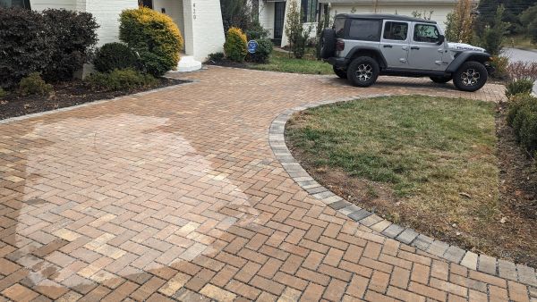
The ancient technology of porous pavement, now a Green Infrastructure (GI) technology, allows stormwater to pass directly through into an underground aggregate reservoir, where it can be naturally filtered and slowly returned either to the existing stormwater infrastructure or, as Bruce K. Ferguson, the author’s professor at the University of Georgia (United States), said, “Get it back into the ground where it belongs.” This simple yet revolutionary concept directly confronts the environmental legacy of our modern paved world.
The widespread adoption of this technology is the direct result of a fundamental shift in policy. This framework effectively requires developers and public agencies to mitigate the environmental impact of impervious surfaces, which positions porous pavements as a premier, multi-benefit solution. By simultaneously providing a durable, usable surface and a high-capacity stormwater management system, porous pavements have become an indispensable tool for modern, sustainable development (Figure 2).
Figure 2. Porous Driveway
Two primary models for crediting porous pavement have emerged and are shaping how projects achieve compliance across the United States. States are increasingly adopting built-upon area (BUA) credit systems to incentivize permeable pavement use. The first credit model is a system of fixed mitigation ratios of porous pavement to impervious area, such as roofs, parking lots, roadways, etc. The second credit model is a system of performance-based standards that rewards design innovation by requiring the porous pavement design to manage a specific volume of runoff. An examination of jurisdictions across the country reveals a diverse tapestry of these approaches, each tailored to unique regional challenges and priorities.
The Regulatory Framework and Mechanics of Mitigation At the project level, this requires enumerating and offsetting new and possibly existing impervious surfaces with porous pavement systems with a deep, open-graded aggregate storage bed. This has become a premier tool for achieving mitigation. Jurisdictions credit these systems through two primary BUA credit system models:
Fixed Mitigation Ratios: This prescriptive approach offers developers clarity and predictability. It establishes a straightforward ratio, such as 1:1, where one square unit of porous pavement fully offsets one square unit of impervious area. While simple to implement, this model may sometimes fail to account for unique site conditions that might warrant a more tailored solution.
Performance-based Standards: This flexible, outcome-driven model focuses on achieving a specific retention goal. Instead of a fixed ratio, a project must demonstrate through design calculations that its system can capture and infiltrate the required volume of runoff. This is typically the “water quality design storm” or “first flush” (e.g., the first 1 or 1.5 inches [2.5 to 3.8cm] of rainfall). This approach encourages innovation and often leads to de facto ratios.
A National Tour of Jurisdictional Policies The application of these system credit models varies significantly, tailored to regional climate, geology and environmental priorities.
East Coast
Maryland: As a pioneering state, Maryland’s Environmental Site Design (ESD) mandate sets a high bar. Montgomery County’s RainScape Program exemplifies a clear, ratio-based approach, offering a 1:1 credit for porous pavement with verified infiltration.
Pennsylvania and New Jersey: Following a similar path, Pennsylvania’s statewide BMP Manual guides local policy. The City of Philadelphia, through its ambitious “Green City, Clean Waters” program, offers a 1:1 offset for high-performing systems designed to infiltrate 90% of annual rainfall. New Jersey’s stormwater rules have evolved to explicitly mandate the use of GI.
New York City (NYC): Facing immense pressure from combined sewer overflows, NYC employs an aggressive 1.5:1 ratio, requiring a 1.5-unit area of permeable surface for every 1-unit area of new impervious in critical zones.
North Carolina: The stormwater design manual for the North Carolina Department of Environmental Quality states that “infiltrating permeable pavement is considered as 100% pervious” for the purpose of BUA calculations and reducing the volume of stormwater. The Charlotte Stormwater ordinance grants 1:1 BUA credit ratio for infiltrating porous pavement meeting state standards. (Figure 3).
Figure 3. Porous pavers in Charlotte, North Carolina, United States.
Midwest
Minnesota: The Minnesota Pollution Control Agency (MPCA) requires porous pavement designs to retain the 1.1-inch water quality storm. The MPCA manual has critical specifications for freeze-thaw resilience, such as requiring deeper aggregate bases (1 in or 30 cm) to prevent frost heave.
Illinois: Chicago also uses a performance-based standard and requires developments to retain runoff from a 1.5-inch (3.8-cm) rainfall event. Chicago’s internationally recognized Green Alley Program has retrofitted over 300 miles (480 km) of alleys with permeable surfaces. It stands as a testament to city-scale implementation and its dual benefits of stormwater management and neighborhood revitalization.
Southeast
Georgia: Atlanta employs a flexible, outcome-driven BUA Credit System where projects must manage runoff to match pre-development hydrology, which makes site-specific design calculations paramount.
Florida: Regulation is complex, managed by the state’s Department of Environmental Protection and powerful regional water management districts. This regulation has effectively made low-impact development (LID) and GI standard practice in urbanized areas.
Alabama: While state-level mandates are emerging, local initiatives in cities like Mobile and Birmingham are beginning to incorporate LID principles to address local flooding and water quality issues.
Northwest
Washington: Both the eastern and western state stormwater management manuals recognize permeable pavements as a preferred practice, granting a 1:1 mitigation credit that can drop to 0.5:1 in areas with little infiltration capacity. Seattle’s code requires systems to manage the runoff from a specific six-month, 24-hour storm event.
Oregon: Prioritizes porous pavements to protect key watersheds. Portland’s “Green Street Policy” requires permeable surfaces in public projects and offers a 1:1 ratio for private systems. Projects are often paired with tree trenches to achieve multiple green goals. Eugene encourages permeable pavements in redevelopment projects exceeding 500 square feet (46.5 m2) of new impervious area.
California
Bay Area (San Francisco, Oakland, San Jose): Follows the BASMAA (Bay Area Stormwater Management Agencies Association) Post-Construction Manual, which credits porous pavements as “self-treating” while also managing runoff from other surfaces.
Los Angeles (LA) County: The LA County LID Standards Manual focuses on retaining the 85th percentile storm volume on-site, which makes porous pavement a primary tool for volume capture.
San Diego Region: Employs a highly technical, performance-based approach that requires projects to meet water quality and stringent hydromodification (flow control) standards.
Key Drivers, Challenges, and the Path Forward This diversity in policies is not arbitrary; it is shaped by a confluence of local environmental realities and practical challenges. Jurisdictions tailor their rules based on the following:
Geology and Soil: Infiltration capacity dictates design feasibility and credit ratios. (Figure 4.)
Climate: Cold climates require frost-resistant designs, while rainy regions prioritize high-volume storage and arid regions prioritize groundwater protection.
Watershed Sensitivity: Critical areas like the Chesapeake Bay, Lake Superior or urban combined sewer overflow zones impose the strictest standards.
Figure 4. Field testing for infiltration.
Despite their proven benefits, challenges related to higher upfront costs and long-term porous pavement maintenance persist. However, innovative programs demonstrate that government policies can successfully drive adoption.
The national policy landscape has unequivocally shifted in the last decade. The conversation is no longer can or if a project must mitigate its impervious footprint, but how. By providing a dual-function solution that is a land use and a stormwater treatment facility, porous pavements have become an indispensable tool. They allow our cities to grow more intelligently, while providing cleaner water, reduced flooding and a more resilient, sustainable future.
About the Expert • Christoper J. Estes is president of Estes Design and owner of Anglesy Construction companies in North Carolina, United States. Specializing in LID design build and environmental compliance, Estes has published hydraulic research and contributed to The Engineering Guide to LEED New Construction.
Strengthening the Association and Communities We Serve
As we enter a new season, I am filled with pride and optimism about the strides we are making together as an organization. The past months have been a testament to the power of collaboration and the impact of our collective voice. I am excited to share some key highlights and future initiatives that will continue to strengthen the International Erosion Control Association (IECA’s) presence and influence in the field of erosion, sediment control and stormwater management.
Strengthening Relationships Through Lobby Days This June, IECA President Jerry Sanders and I traveled to Washington, DC, United States, for GMA (Geosynthetic Materials Association) Lobby Day, which is a pivotal event that allowed us to engage directly with members of Congress and their staffs. During this visit, we emphasized the importance of sound erosion and sediment control practices and shared insights on stormwater management. One of the highlights was our meeting with representatives from the Environmental Protection Agency, where we worked to deepen our partnership and improve communication channels. These discussions are laying the groundwork for a stronger mutual understanding and collaboration that will benefit our industry and the communities we serve.
But our work doesn’t stop here. In December, we will return to Capitol Hill to continue these important conversations. Our goal is to establish IECA as a trusted resource for lawmakers and help them make informed By reiterating our commitment to science-based practices and education, we aim to position IECA as an indispensable partner in shaping sustainable solutions for erosion, sediment control and stormwater challenges.
Looking Ahead to Fort Worth While we focus on advocacy today, we are equally thrilled to look ahead to our Annual Conference and Expo, taking place in Fort Worth, Texas, United States, from March 1–3, 2026. This premier event will bring together industry experts, innovators and leaders from around the globe to share knowledge, network and explore the latest advancements in our field. Whether you are a seasoned professional or new to the industry, the Annual Conference provides an unparalleled opportunity to expand your expertise and make lasting connections.
Fort Worth’s vibrant culture and deep-rooted history make it the perfect backdrop for our gathering. With engaging sessions, cutting-edge exhibitors and a host of networking opportunities, we’re confident this year’s conference will be one of our most impactful yet. Mark your calendars now. You won’t want to miss it!
A Shared Vision for Progress As members of IECA, you are the heartbeat of this organization. Your dedication and expertise inspire us to push boundaries and explore new horizons. Together, we are building not just a stronger association but also a more sustainable future for the communities we serve.
Thank you for being a part of this journey, for lending your voices to the discussions that matter and for continuously driving innovation and excellence. I look forward to seeing many of you at our regional conferences and, of course, in Fort Worth next March. Let’s continue to make an impact!
Judith M. Guido
Chairwoman / Founder,
Guido & Assoc.
Each day, I work with clients on profitably scaling up their companies by developing a unique strategy that focuses on high-payoff activities so they can execute efficiently, develop their workforce and always have enough cash to invest in their growth. I also work with owners and management teams that are looking to sell their companies or acquire a company. I am always focused on ways to create real value.
By “real value,” I mean value that customers are willing to pay for, bankers are willing to lend to, people are drawn to work for, and buyers are willing to pay good money to acquire. And yet, “value” is one of the most misunderstood words in business today. Ask 10 people what it means, and you’ll get 20 different responses. And whether you’re working on profitably scaling your company or preparing to buy a company or sell yours, there are some particularly important and basic activities you can do that will create real value.
In the ever-changing world of business, the concept of value stands as both a guardrail and a cornerstone for success. It goes beyond financial gains incorporating a range of attributes that strengthen a company’s position, sustainability and desirability. To really understand value, we must look at both its tangible and intangible aspects.
Financial value is straightforward. It’s the monetary worth of assets, revenue, profits and EBITDA (Earnings Before Interest, Taxes, Depreciation and Amortization) that can be quantified and evaluated. This is the value that shareholders often prioritize, as it directly impacts the valuation (worth) of the business. Qualitative value is equally important. It includes reputation, name awareness, brand strength, customer satisfaction, strength of the team and a strong and unified culture. And what really escalates value is the uniqueness of a company’s strategy, business models and processes that propel the business forward.
To clarify what constitutes real value, we should consider the diverse perspectives within the erosion control and environmental sectors and how value can be defined in terms of both environmental contributions and economic viability. It may seem like common sense (there’s nothing common about common sense), but if you want to generate multi-faceted value you should focus on investing in sustainable practices and services that safeguard the environment while delivering high margins. Not all practices and services are created equally when it comes to margins.
It is essential to spend as much time with customers to understand what they value so that you can enhance their experience by making it easy for them to collaborate with you. Then you can deliver the exceptional service and engagement they expect and need. The more time you spend with customers, the easier it will be for you and your team to innovate continuously to stay ahead in the market and meet evolving customer and regulatory demands. This innovation will also help to foster a positive organizational culture that motivates and retains top talent. Maintain transparency and ethical standards to build trust and credibility with all stakeholders.
Ensure you have the talent and skillsets inside and outside of your organization to build relevant and robust fiscal management systems that ensure cash flow, profitability and growth. As such, develop strong networks and relationships with financial partners and stakeholders, as well as the local community. With these partners, develop and implement efficient, high-payoff operational processes that reduce costs and increase productivity. And wherever you can embrace technology and artificial intelligence to streamline operations and offer innovative solutions, do it.
Focus on short- and long-term strategic planning to secure future success and adaptability. These steps not only create financial and qualitative value; they also underscore a realistic definition of value.
That definition will resonate with key stakeholders in the erosion control and environmental industries who are committed to ecological stewardship and sustainable development.
About the Expert • Judith M. Guido is the chairwoman and founder of Guido & Associates, a business management consulting firm in the erosion control and green industry. Guido can be reached at 818.800.0135 or judy@guidoassoc.com.
Rich McLaughlin, Ph.D.
Professor Emeritus
North Carolina State University, Raleigh, NC
Controlling wind and water erosion can involve temporary measures, establishing permanent vegetation or managing the existing vegetation. A recent study in China tested five options for short-term erosion control on stockpiled soil.1 The erosion control methods included sod or seeded grass in full coverage or only in a strip at the bottom of the slope, as well as artificial turf in complete coverage. Tests were conducted in a flume, measuring 3.00 m by 2.00 m by 0.45 m (length by width by depth; 9.8 feet by 6.6 feet by 1.5 feet), filled with a sandy loam fill soil and tilted to a 30-degree slope. Test conditions included Zoysia sod with full coverage or only the bottom 75 cm (2.5 feet), seedling mondograss (Ophiopogon japonica; 10 cm [4 inch] height) at 100 plants m2 (9 plants feet2) with full coverage or only the bottom 75 cm (2.5 feet), or artificial turf (1.5 cm [0.6 inch] height) with full coverage. Simulated rainfall was applied at a rate of 1.45 mm/min-1 (3.5 inch/hour-1), which represented natural events recorded in the area. Each rain event lasted for 45 minutes after runoff initiation, with samples being taken periodically during the event as well as flow measurements. Compared to bare soil, sodding delayed runoff more than the other covers, but all delayed it substantially. The strips delayed runoff by 35% to 50% of full coverage. Erosion rates were reduced by 88% to 99%, with seedlings the least effective and sod the most. The sod strip was almost as effective as full sodding, and the seedling strip was 83% as effective as full coverage. While all three full coverage treatments significantly reduced total soil loss, the seedling cover was not as effective as sod or artificial turf.
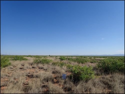
Changes in vegetation in arid and semiarid regions have been documented globally and are attributed to climate change, invasive species and grazing management. These areas can be major sources of sand and dust storms that affect wide areas downwind. The effects of different types of vegetation on wind erosion rates were recently quantified on the Chihuahuan Desert in New Mexico, United States, over five years.2 The four vegetation types included:
historic grasses (black grama)
shrub-invaded (black grama, honey mesquite)
shrubland (honey mesquite, some bunchgrass)
grassy shrubland (honey mesquite and bunchgrass).
Erosion was clearly evident in the latter two states (Figure 1). Plots of 100 by 100 m (328 by 328 feet) were established for each vegetation type, and the vegetation cover was determined annually by line transect. Sediment transport was determined from sediment sampler towers on each plot, capturing sediment at four heights up to 0.85 m (2.8 feet). The historic grassland had vegetative cover of 35% to 80% and bare soil of 18% to 40%, compared to the shrubland having 19% to 25% vegetative cover and up to 66% bare soil. These values appear to be representative of data collected elsewhere in the area. The mass flux of sediment increased tenfold between the historical grass cover and the shrub-invaded and another tenfold in the shrubland, while the shrub-invaded area had wind erosion similar to the historical grass area. The implications for site management (grazing control) are discussed. The authors suggest the need to maintain a minimum of 20% grass cover to minimize risks of wind erosion, further site degradation and sandstorms and dust storms. Relatively small changes in grass cover can result in substantial increases in wind erosion, rapid loss of the remaining grass and changes in the ecological state and function of an area.
Figure 1. Photos of the four vegetation cover types in the Webb et al. (2024) study (clockwise from top left): Native grassland, shrub invaded, grassy shrubland, and shrubland. Photo credit: Justin W. Van Zee.
References
Jian P, Li J, Wang W, et al. 2025. Study on the Effectiveness of Temporary Vegetation Measures on the Regulation of Runoff, Sediment Yield, and Hydraulic Characteristics on the Spoil Heaps. Land 14:951. doi.org/10.3390/land14050951.
Webb NP, Wheeler B, Edwards BL, et al. 2025. Magnitude Shifts in Aeolian Sediment Transport Associated with Degradation and Restoration Thresholds in Drylands. Journal of Geophysical Research: Biogeosciences, 130:e2024JG008581. doi.org/10.1029/2024JG008581.
About the Expert
• Rich McLaughlin, Ph.D., received a B.S. in natural resource management at Virginia Tech and studied soils and soil chemistry at Purdue University for his master’s degree and doctoral degree. He has retired after 30 years as a professor and extension specialist in the Crop and Soil Sciences Department at North Carolina State University, specializing in erosion, sediment and turbidity control. He remains involved with the Department as professor emeritus.