
Unmanned aircraft systems increase inspection efficiency in North Carolina
EROSION AND SEDIMENT CONTROL (ESC) inspectors help prevent sediment from active construction sites from being lost into aquatic environments, walking sites to ensure compliance with ESC plans by checking that erosion control measures are properly installed and in good working order. But walking large or complex sites can be time-consuming, physically demanding, and logistically challenging.
A recent study conducted in Wake County, North Carolina, examined the efficiency and effectiveness of using unmanned aircraft systems (UASs)—more commonly known as drones—for sediment and erosion control inspections. After conducting 15 field and drone inspections at five different sites, the study found that using a drone can save substantial amounts of time and still identify most noncompliant issues on a site.
Traditional Inspections vs. Drones
To conduct the study, inspectors in Wake County compared traditional methods and UAS technologies. Traditional methods consisted of a field inspector who walked the site and documented compliance issues with a point-and-shoot 20.1 MP digital camera with an 8x optical zoom. UAS inspections were accomplished with a 6K camera drone with a 7.9″ smart controller. A 6K camera drone captures twice the number of pixels as a 4K camera drone, offering better image quality even when zooming in on a subject.
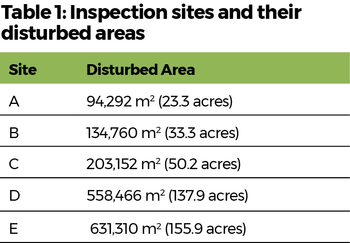
The evaluations looked at five active, permitted construction sites in the Piedmont region, which is known for its clay-rich soils, rolling hills, and humid climate. These conditions can present erosion control challenges throughout a project’s duration, and the disturbed areas varied across the sites (Table 1).
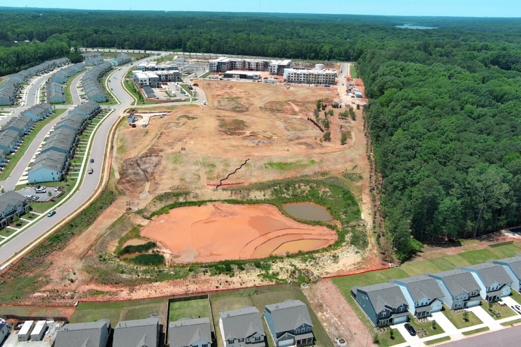
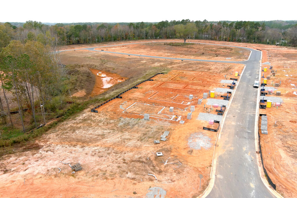
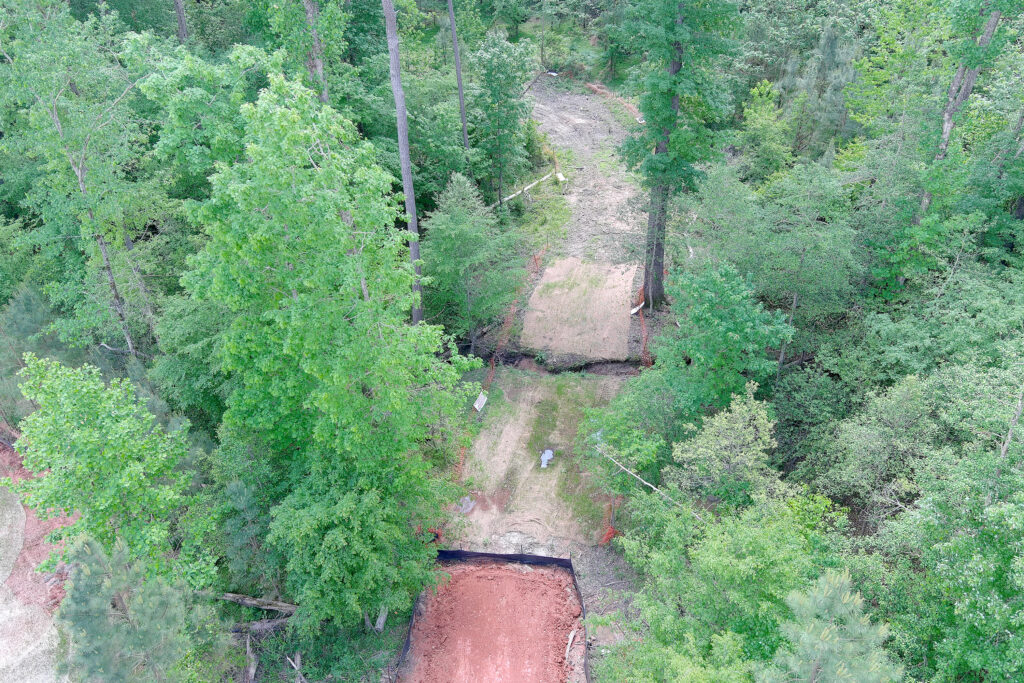
Drone inspections were performed by flying the UAS, taking photos of the site (Fig. 1), and documenting all noncompliant items observed. The drone was controlled manually within the pilot’s line of sight to ensure that one inspector could conduct drone inspections, and one could conduct comparable field inspections simultaneously.
A typical flight consisted of flying the drone around the perimeter of the site at about 23 m (75 ft) above ground level with the camera angled at 45° towards the perimeter silt fence. The drone was then flown at the same height around other measures such as sediment basins and diversion ditches to take photos at different angles and positions.
The drone was then flown at altitudes of approximately 61–122 m (200–300 ft) to get comprehensive overview photos of the site. These helped document ground cover stabilization. The amount of photos taken at a 63,1310 m2 (156 acre) construction site averaged between 90 and 115. No video footage was taken; researchers found that examining still photos for noncompliant items on a computer screen following an inspection was more efficient.
Inspectors uploaded the UAS photos to a computer, reviewed them, and entered them into an inspection report. The drone inspection report was then compared to field inspection results generated by an inspector walking the same site, at the same time, and photographing and otherwise documenting each noncompliant item.
Each site was inspected on three different days between Jan. 19, 2023 and July 3, 2023, allowing adequate time between inspections to allow for corrective measures or additional maintenance. Inspectors then compared the number of noncompliant items observed in walking a site to the total observed on the photos captured by the drone.
Researchers compared the median percentages of noncompliant items observed, as well as the total time each inspection took; the field inspector marked the time he started to walk and the time he finished, while the drone inspector included the time it took for pre- and postflight drone checks and flight times. Time spent examining photos and creating an inspection report was also included in the total inspection times.
Results Reveal Time Savings
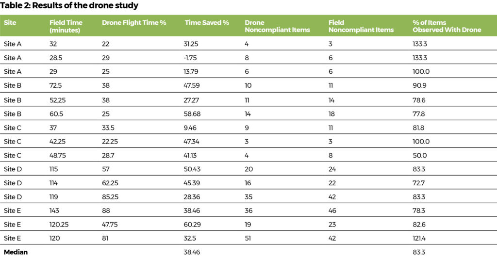
The effectiveness of observing noncompliant items with a drone inspection versus a field inspection varied by site and inspection (Table 2). The median amount of noncompliant items observed among all drone inspections was 83.3%; they typically missed issues such as minor damage to perimeter silt fences and silt fence outlets. Drone inspections identified most noncompliant sediment and erosion control measures not along the perimeter of a site.
A few drone inspections identified noncompliant measures that the field inspector had missed, including areas that required stabilization, yard inlet protection, and silt fences around lots. Most were on the two larger sites, which had a lot of active home construction sites with individual lot sediment and erosion control measures.
Drone inspections saved an average of 38.46% of the time required for traditional inspections. The least efficient inspection was 13.8% faster at the smallest site of 94,292 m2 (23.3 acres), and if this site was omitted from the study, the average time saved across all sites would increase to 42.6%. That means a two-hour field inspection could potentially be reduced to 69 minutes with the use of a drone.
The total time included the time needed to review photos and create an inspection report with photos. A typical breakdown at Site E included 88 minutes of total drone-related operations: 37 minutes for the actual drone flight and 51 minutes for photo review and report writing.
Traditional field inspection took 143 minutes, including 103 minutes walking the site and 40 minutes for the field inspector to review photos and write a report. Time spent in flight for the drone inspections was significantly less, but photo review and report writing took longer.
The Wake County study shows that the use of drones can help ESC inspectors decrease the time spent on inspections, especially on larger sites. It also shows that drones are effective at identifying most noncompliant items during inspections. UAS systems can’t replace a full-time, trained ESC inspector, but it can take years to train and develop staff.
Additional Benefits
Flying a drone for inspections reduces human exposure to dangerous site conditions such as slippery slopes, trenches, extreme heat, snakes, etc. With decreased inspection times, more inspections can be conducted, and having an increased inspector presence on-site could have a positive effect on compliance. Another benefit might be the ability to easily document and track large areas of disturbed soil that need to be stabilized within regulatory timeframes.
We wouldn’t recommend flying a drone for every inspection at every site. Instead, ESC professionals might alternate drone and field inspections. Using multiple drones at a single site is also not recommended; it would likely negate any time savings offered over traditional methods.
It can be difficult to document all of the disturbed areas on a large construction site and ensure they are stabilized within seven to 14 days—the mandated timeframes for ground stabilization under North Carolina’s Sedimentation and Pollution Control Act. Having an inspector take aerial photos with a drone and increase inspection frequency could help increase ground cover, leading to lower stormwater turbidity levels leaving the site.
Study Challenges
Training new pilots, obtaining permission from landowners and developers, and maintaining line-of-sight on large projects were the main challenges the Wake County study faced. The Federal Aviation Administration requires pilots to maintain visual line of sight of the drones they operate and limits drone flight elevation to 121.92 m (400 ft).
The state of North Carolina requires drone pilots to get permission to launch and recover drones from property owners. Privacy concerns can also be an issue when flying drones. Pilots must avoid any violations of privacy when capturing images.
Soil type and topography may affect results; many of the sites in this study benefited from the orange soil color of the Piedmont region. Drone inspections might be less effective in areas where the soil color is less distinctive. Areas that feature more varied topography may also affect UASs’ time saved and effectiveness. Also note that this study was relatively small; larger studies are recommended.
With drone technology improving rapidly, however, UASs are likely to play a larger role in future erosion and sediment control inspections. Emerging capabilities such as drones that launch automatically from an on-site docking station and upload photos weekly show great promise for ESC inspections. The sky’s the limit!
About the Expert
Andrew Lake is an environmental consultant with Wake County, North Carolina. He has worked in water quality for more than 15 years and holds CPESC and CESSWI certifications.


